
Rick McBee's Writings
Explore the magic of new ideas and books to read as well as see what books I have written, my favorite photos, my opinions on may subjects, including Science, Africa, the Caribbean, the Civil War, my Book Reviews, and Much More!
U.S. National Orienteering Championships – 2019

Talk about a “Happening”! The 2019 USA National Orienteering Championships, http://www.us.orienteering.org/orienteers/on-foot/results , hosted by the Bay Area Orienteering Club, http://baoc.org/wiki/Schedule/2019/US_Nationals , of the San Francisco, California area, was attended by over 200 persons featured the USA National Competitions in over 20 age and ranking categories from age 12 up through and including age 80+.
Although the hype of the event is generally around the US National and Junior National team members competitions, at all age levels there were sufficient contestants and courses to keep everyone active and involved for the full three day event in Big Basin Redwoods StatePark, https://en.wikipedia.org/wiki/Big_Basin_Redwoods_State_Park , and on the Campus of Cabrillo College, https://www.cabrillo.edu/.
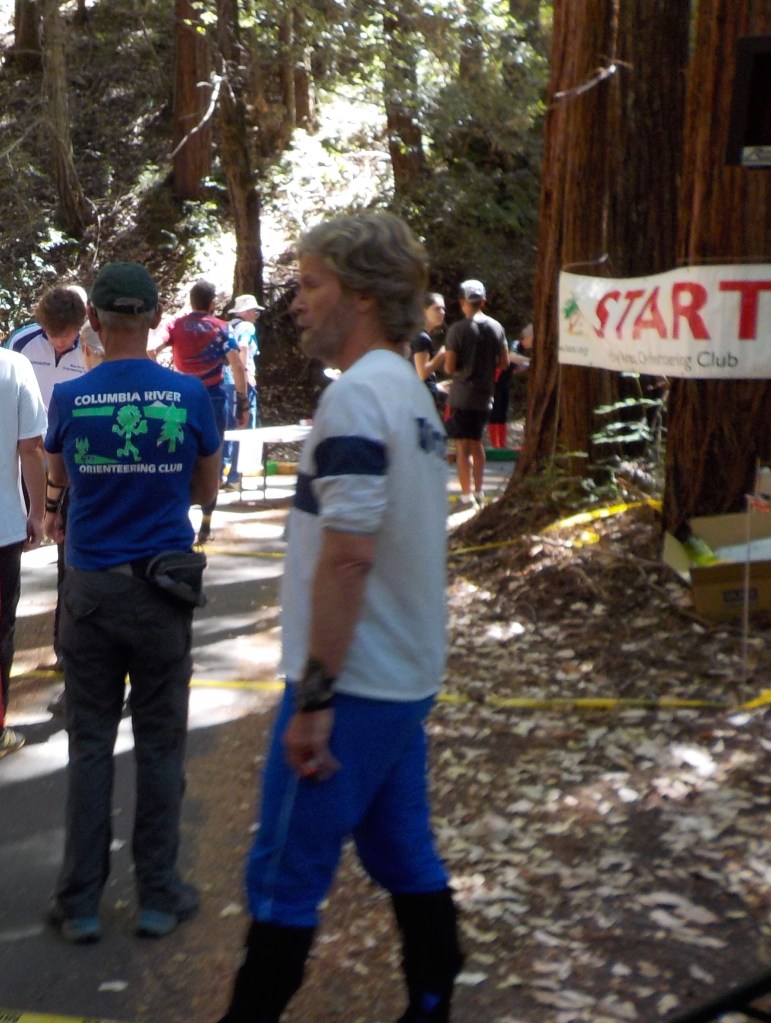
In Orienteering for any race, each competitor in an age group starts at least three minutes apart from other members of that group. This is to prevent following. Here I am among the redwoods of Big Basin (Back turned in Blue Columbia Gorge Orienteering Club shirt) waiting at the start to be called up for the beginning of the Middle Distance event.
There were a total of six different competitions in which participants could vie for superiority: Sprint, Middle Distance, Long Distance, Relay and Temp-O. As always in top notch competitions, any slight blunder is enough to knock winning contenders down to lesser medals or out of the winner’s circle completely. So let’s see how I did on the Middle distance for my medal. You can see all of the event information at the BAOC US National Web Site: http://baoc.org/wiki/Results/2019/US_Nationals
The Middle Distance map for my age group, 75+ years of age is below: Note it’s only 2 kilometers (1 1/4 miles in length) but there is an elevation change of 125 meters (that’s 410 feet) which pulls a lot of energy out of the legs as you go cross-country using only a compass and map for reference and trying to avoid as much of the green (especially the dark green of impenetrable evergreen huckleberry thickets in the steep open redwood forest. By open, I don’t mean nice and smooth as there are downed timber patches of three and four foot diameter logs and short underbrush along the way not counting streams and cliffs that must be crossed or navigated around while not losing one’s orientation and sense of direction while going as fast as possible.

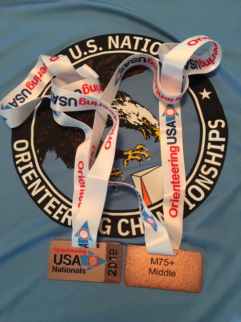
When I took off at “triangle which marks the start, I was pumped up for the race. Arriving from the start to control # 1 was a cinch, the westernmost end of a shallow ditch, but I got over confident on #2 and wasted 8 minutes which likely cost me a chance at either the Gold or Silver Medals. When I found #2, the depression the route to #3 was obvious, cut over to the stream that runs just North of #2 and follow it up hill in an almost brush-less corridor until I have to cross the deep ravine of the creek to reach the spur which ran between two sections of the stream. At this point I saw one of the fastest 70+ competitors whom I knew had started right after me, so I knew others were having difficulties with 1-2 and I was catching up with anyone in my age category who might have passed me during my “brain fart” between 1 and 2. My time from 2-3 was the fastest for our group and I picked up 10 seconds on the leader. Number 4, northernmost tree in a group of significant lone trees was easy as there was a pretty good clearing to recognize. The ditch at #5 was shallow and required a bit of a detour to the north to skirt the think underbrush, but if you were keeping your attention on the map and cut the trail, it was like following a handrail. Getting to the knoll of #6 was simply a matter of straight-line navigating as long as you compensated for each of the little jogs that came in getting around some of the denser brush in between. The clearing for #7 had a lot of dark green brush in between on the direct route, so I cut NNW to hit the trail, turned left and followed the trail to the junction and then cut upwards. Heading to #8 I took a chance and just bush crashed down the slope from 7 and was able to find a quick way across the stream and up the hill to the trail. I then followed the trail until I was NNE of the knoll and cut up through the open timber to that control. This was a great move because I had the fastest time for our group on this leg and actually picked up two whole minutes on the leader. Getting to #9 was a straight line dash and then I cut directly to the road to hit #10 and then sprinted down the flagged chute for the double circle which is the finish. Again I had the fastest time for our group on this leg, although the measly 1 second (15 sec. vs 16 sec.) is really nothing other than bragging points. You can see my win/spit times for each leg of the course along with other members in that 75+ race at: http://obasen.orientering.se/winsplits/online/en/default.asp?page=table&databaseId=65392&categoryId=14 . Hope you enjoy the description. My Bronze Medal front and back below on top of the great T-shirt for the event.

South Africa Book Group on Goodreads
.gr_grid_container { /* customize grid container div here. eg: width: 500px; */ } .gr_grid_book_container { /* customize book cover container div here */ float: left; width: 39px; height: 60px; padding: 0px 0px; overflow: hidden; }
 1557 members
This is a book club for all South Africans who love reading! We also have members from other coun...
Books we've read


View this group on Goodreads »
Share book reviews and ratings with South African Book Lovers, and even join a book club on Goodreads.
